Cardiganshire
By [Budgen, Thomas] – Draughtsman [see page for license], via Wikimedia Commons
History
Cardiganshire is a traditional county in Wales that came into being in 1282.
In 1282 Edward I conquered the principality of Wales and divided the area into counties. The name Cardigan was an anglicization of the name for the historic kingdom of Ceredigion. The area of the county became a district under the name Ceredigion in 1974 under the Local Government Act 1972, and since 1996 has formed the county of Ceredigion.
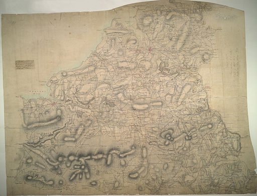
Geography
Cardiganshire is a maritime county bounded to the west by Cardigan Bay, to the north by Merionethshire and the River Dovey, to the east by Montgomeryshire, Radnorshire and Brecknockshire, and to the south by Carmarthenshire and Pembrokeshire. The county has an approximate population of 64,000. The Cambrian Mountains cover much of the east of the county. In the south and west the surface is less elevated. The highest point is Plynlimon at 2,486 feet (758 m) at which five rivers have their source: the Severn, the Wye, the Dulas, the Llyfnant and Rheidol, the last of which meets the Mynach in a 300 foot (100 m) plunge at the Devil’s Bridge chasm. The 50 miles of coastline has many sandy beaches.
The main towns are Aberaeron, Aberystwyth, Cardigan, Lampeter, New Quay, Newcastle Emlyn (partly in Carmarthenshire) and Tregaron. The chief river is the Teifi which forms the border with Carmarthenshire and Pembrokeshire for much of its length. Tourism and agriculture, chiefly hill farming, are the most important industries.
Source – Wikipedia Cardiganshire
Queries and Surnames
Submit and View Queries and Surnames Submit a Query or Surnames for your lost Cardiganshire ancestor. Please use the linking feature only for genealogical material otherwise your query may be deleted.